Exeter MR Research Centre
How To Get To The Centre
The MRI Centre is located within the University of Exeter Medical School (UEMS), within St Luke's Campus, University of Exeter.
To print the direction with the map please click here (PDF file).
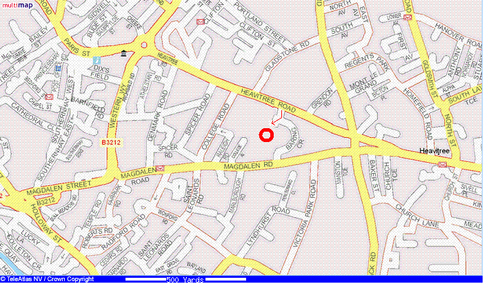
Location map
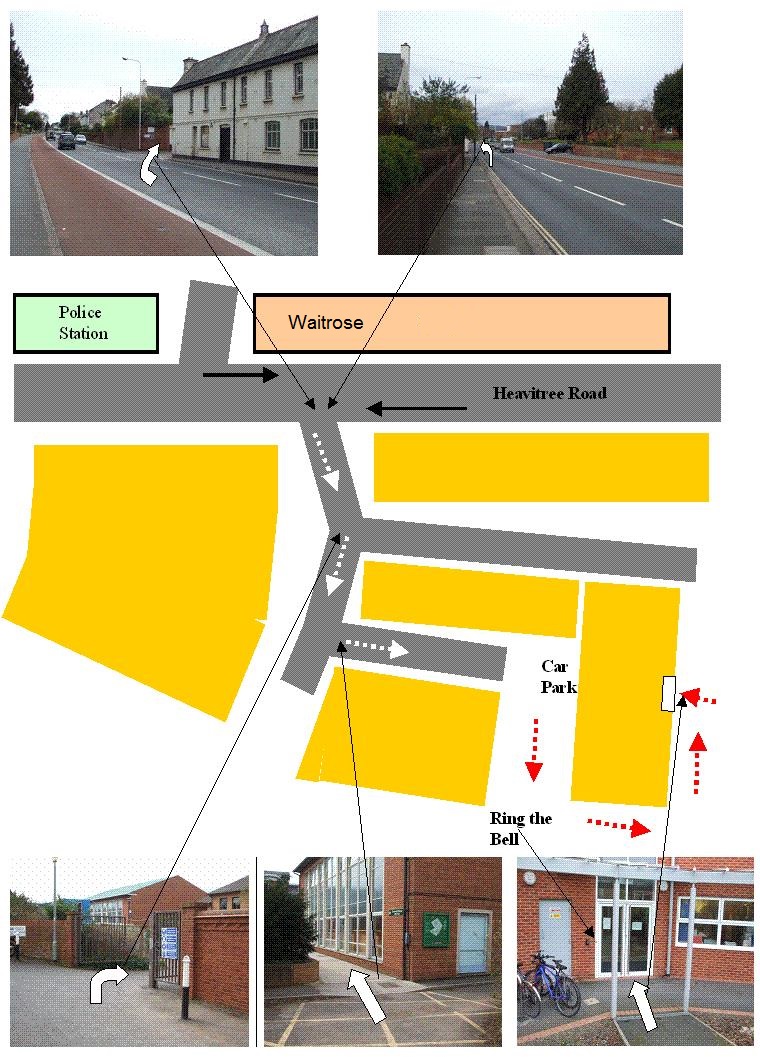
Detailed map
Directions
This map was Tuesday, 2 October, 2012
BY ROAD
If driving to St Luke's, parking is available in the car park that is accessible via Magdalen Road.From the East (via M5):
Leave the M5 at junction 30. Take the third exit (A379) and join the A3015 (signposted initially for Marsh Barton). You will join the Countess Wear Roundabout at which point you should turn right to join the Topsham Road Carry on for approximately 1 mile until reaching traffic lights for which the right turn is signposted to Royal Devon and Exeter Hospital (Wonford). Take this turn (Barrack Road), and carry straight on, crossing over the first set of traffic lights, passing the hospital on your right until a second set of traffic lights at a junction is reached at Magdalen Road.Turn left and the car park is a further 200 metres on the right hand side.From the West (Via A30):
Join the M5 at junction 31and carry on to junction 30. Come off and join the A3015 (signposted initially for Marsh Barton). You will join the Countess Wear Roundabout at which point you should turn right to join the Topsham Road carry on for approximately 1 mile until reaching traffic lights for which the right turn is signposted to Royal Devon and Exeter Hospital (Wonford). Take this turn (Barrack Road), and carry straight on, crossing over the first set of traffic lights, passing the hospital on your right until a second set of traffic lights at a junction is reached at Magdalen Road.Turn left and the car park is a further 200 metres on the right hand side.From the West (Via A38):
Come off the A38 at the A379 junction and follow signs for Topsham. Cross over the first roundabout and then left at the second to cross over the river. At the next roundabout (Countess Wear Roundabout) turn left to join the Topsham Road and carry on for approximately 1 mile until reaching traffic lights for which the right turn is signposted to Royal Devon and Exeter Hospital (Wonford). Take this turn (Barrack Road), and carry straight on, crossing over the first set of traffic lights, passing the hospital on your right until a second set of traffic lights at a junction is reached at Magdalen Road.Turn left and the car park is a further 200 metres on the right hand side.BY RAIL
From the West (Via A38):
Exeter has two railway stations - Exeter St. David's (main Inter City station) and Central. Exeter St. David's Station is approximately a mile and a half from St Luke's Campus and Central Station about three quarters of a mile and taxis are available from both. The average journey time from London Paddington is 3 hours to Exeter.Walking directions to the University (St Luke's Campus) from Exeter St. David's Station:
The University is located approximately half a mile from St. David's Station. Leave the station via the main booking hall, and walk across the forecourt keeping to the right of the car parking area. You will meet Bonhay Road. Cross over at the traffic lights and join the path straight in front of you, which is signposted for the walking route to the city centre. Follow this path (which is quite steep) until it joins St David's Hill at which point turn right. Continue up the hill until North Road is joined at which point turn right and keep going until the large clock tower is reached. Cross directly over to join Queen Street and carry on walking in a straight line for about 400 meters (passing Central Station and the museum), at which point the main High Street is joined. Turn left and carry on until reaching the crossing of North road and Paris street (Debenhams is on this corner). Turn right to join Paris Street and continue on until the roundabout at the bottom, crossing over to join Heavitree Road. Continue up the hill and St Luke's Campus is approximately 200 metres further on , between the intersection of Heavitree Road and College Road.Walking directions to the University (St Luke's Campus) from Central Station:
Come out of the main entrance and turn left onto Queen Street. Carry on walking in a straight line for about 200 meters, passing the museum, at which point the main High Street is joined. Turn left and carry on until reaching the crossing of North road and Paris street (Debenhams is on this corner). Turn right to join Paris Street and continue on until the roundabout at the bottom, crossing over to join Heavitree Road. Continue up the hill and St Luke's Campus is approximately 200 metres further on , between the intersection of Heavitree Road and College Road.BY BUS
From the Bus Station:
A wide range of services run to the bus station, which is approximately 400 metres from St Luke's campus. This is link to the local bus timetables (select timetable search).To walk from the bus station it is necessary to join Paris Street, the road onto which buses leave the station. Turn left, and cross the roundabout at the bottom to join Heavitree Road. Continue up the hill and St Luke's Campus is approximately 200 metres further on , between the intersection of Heavitree Road and College Road.
BY AIR
The nearest regional airports are at Exeter and Plymouth.
top
![]()
![]()
![]()
![]()
![]()